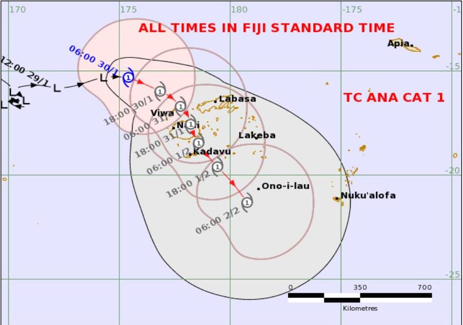
Tropical Cyclone Ana is likely to make landfall over Ra Province around tomorrow morning then continue to move southeastwards over Viti Levu and track close to Kadavu around tomorrow night to Monday morning.
This is according to a the latest release by the Fiji Meteorological Service today.
The release said TC Ana continues to move closer towards Fiji and was located about 175km northwest of Viwa at 9am today.
The system is expected to slow down as it moves over the group.
The eye of TC Ana is expected to be located closer to the Yasawa Group tonight and approach Viti Levu early tomorrow whilst remaining as a category 1 cyclone.
“Please be advised that damaging winds are likely to begin several hours before the cyclone centre passes overhead or nearby.
“Gale force winds has been reported over Yasawa-i-Rara this morning and is expected to affect the rest of the Fiji Group from later today.
“Damages to weak structures and houses of very light materials is expected.
“It may also cause disruption of electrical power distribution and communication services. Damages to crops and vegetation with trees tilting due to very strong winds is also likely.”
Meanwhile heavy rain is expected to continue and become more frequent as TC Ana draws closer to Fiji.
“This will cause flooding of roads, villages, towns and communities near streams, rivers and low lying areas.
“Due to continuous rain in the last few days causing soil in the ground to become moist and loose, this poses risk of landslides.
“Therefore, all communities living in flood and landslide prone areas need to remain alert and take precautions when necessary.
“Members of the public are advised to keep away from flooded drains, streams and rivers whilst motorists are also requested to take extreme care when driving as there is risk of poor visibility inareas of heavy rain and thunderstorms.
“Moderate swells and breaking waves reaching the coastal areas may cause possible coastal inundation and sea flooding especially during high tide.
“Sea conditions are too dangerous for sea travel, sailing and other sea activities.
“The current situation is closely monitored.”
Members of the public are advised to remain updated with the latest weather information and adhere to authorities on the ground.