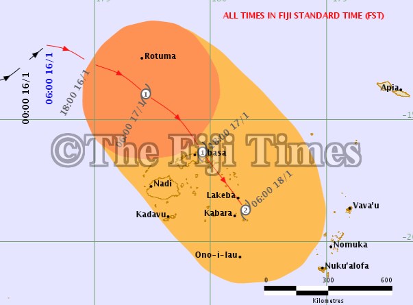
THE weather system that will intensify into tropical cyclone Tino has picked up speed and is now moving at 20kmph towards Rotuma, and then the Fiji group
Based on this forecasted track, TC Tino will make landfall in an area between Coqeloa and Dogotuki in Macuata by 6pm on Friday.
The latest threat map issued by the Fiji Meteorological Department shows TC Tino track has moved away a bit to the North East of Labasa.
It is now forecasted to also make landfall on Taveuni sometime before midnight on Friday before entering the Lau waters as a category one cyclone.
Category one TC Tino will have winds gusts up to 95kmph.
By early Saturday morning, TC Tino will be bearing down on the Lau group as a category two system with wind gusts up to 126kmph.
A tropical cyclone warning remains in force for Rotuma and a tropical cyclone alert remains in force for the Fiji group.
A gale warning remains in force for Rotuma. a strong wind warning remains in force for the Fiji group.
A heavy rain warning remains in force for Yasawa and Mamanuca group, Viti Levu, Lomaiviti group, Vanua Levu, Taveuni and nearby smaller islands and Northern Lau group.
A heavy rain alert remains in force for the rest of the Fiji group.